


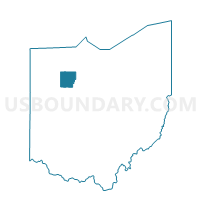
Voting District CASS, Hancock County, Ohio
About
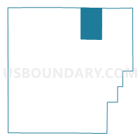
Outline

Summary
| Unique Area Identifier | 647790 |
| Name | Voting District CASS |
| County | Hancock County |
| State | Ohio |
| Area (square miles) | 24.02 |
| Land Area (square miles) | 24.02 |
| Water Area (square miles) | 0.00 |
| % of Land Area | 100.00 |
| % of Water Area | 0.00 |
| Latitude of the Internal Point | 41.12345530 |
| Longtitude of the Internal Point | -83.57365440 |
Maps

Graphs
Select a template below for downloading or customizing gragh for Voting District CASS, Hancock County, Ohio


Neighbors
Neighoring Voting District (by Name) Neighboring Voting District on the Map
- Voting District ALLEN EAST, Hancock County, OH
- Voting District BIGLICK, Hancock County, OH
- BLOOM TOWNSHIP Voting District, Wood County, OH
- BLOOM TWP BLOOMDALE Voting District, Wood County, OH
- Voting District FINDLAY 2F, Hancock County, OH
- Voting District MARION N, Hancock County, OH
- PERRY TWP PERRY Voting District, Wood County, OH
- Voting District WASHINGTON, Hancock County, OH
Top 10 Neighboring County Subdivision (by Population) Neighboring County Subdivision on the Map
- Findlay city, Hancock County, OH (41,202)
- Washington township, Hancock County, OH (4,440)
- Marion township, Hancock County, OH (2,759)
- Bloom township, Wood County, OH (2,609)
- Allen township, Hancock County, OH (2,533)
- Perry township, Wood County, OH (1,605)
- Biglick township, Hancock County, OH (1,106)
- Cass township, Hancock County, OH (993)
Top 10 Neighboring Place (by Population) Neighboring Place on the Map
Top 10 Neighboring Unified School District (by Population) Neighboring Unified School District on the Map
- Van Buren Local School District, OH (6,447)
- Elmwood Local School District, OH (6,292)
- Arcadia Local School District, OH (3,131)
Top 10 Neighboring State Legislative District Lower Chamber (by Population) Neighboring State Legislative District Lower Chamber on the Map
Top 10 Neighboring State Legislative District Upper Chamber (by Population) Neighboring State Legislative District Upper Chamber on the Map
Top 10 Neighboring 111th Congressional District (by Population) Neighboring 111th Congressional District on the Map
Top 10 Neighboring Census Tract (by Population) Neighboring Census Tract on the Map
- Census Tract 3, Hancock County, OH (8,025)
- Census Tract 6, Hancock County, OH (6,875)
- Census Tract 2, Hancock County, OH (5,975)
- Census Tract 1, Hancock County, OH (4,208)
- Census Tract 223, Wood County, OH (3,964)
- Census Tract 222, Wood County, OH (2,643)